
What if a city’s mood could be mapped like weather? Researchers at the University of Missouri are using AI to do exactly that—by analyzing geotagged Instagram posts and pairing them with Google Street View images, they’re building emotional maps of urban spaces.
These “sentiment maps” reveal how people feel in specific locations, helping city planners design areas that not only function better but also feel better. With potential applications ranging from safety to disaster response, this human-centered tech could soon become part of the city’s real-time dashboard.
Human-Centric City Vision
When Jayedi Aman looks at a city, he sees more than streets and buildings. He pays attention to how people move, interact, and experience the spaces around them. Aman, an assistant professor of architectural studies at the University of Missouri (Mizzou), believes that the future of urban design could be shaped as much by human emotion as by concrete and steel.
In a recent study, Aman teamed up with Tim Matisziw, a professor of geography and engineering at Mizzou, to explore the emotional fabric of city life using <span class="glossaryLink" aria-describedby="tt" data-cmtooltip="
” data-gt-translate-attributes=”[{"attribute":"data-cmtooltip", "format":"html"}]” tabindex=”0″ role=”link”>artificial intelligence. Their mission was to uncover how a city’s physical environment influences the way people feel as they navigate it.
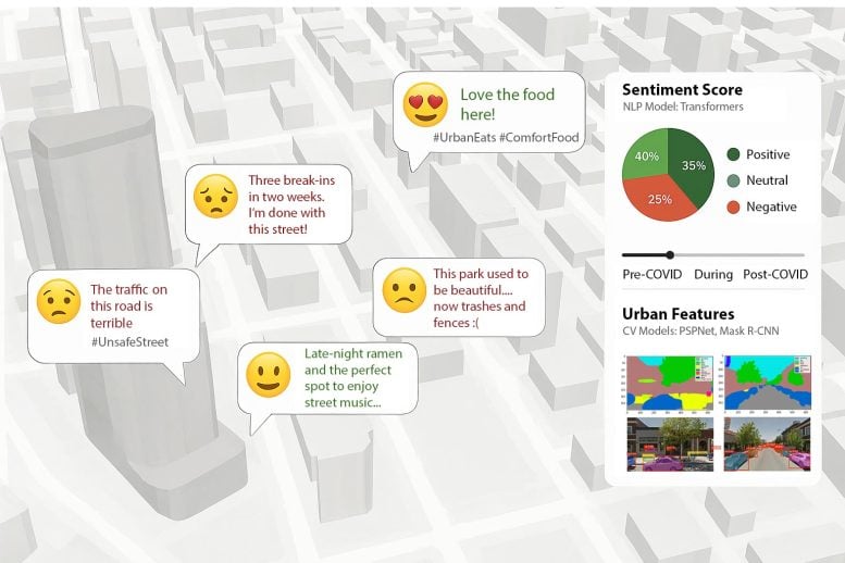
They started by analyzing public Instagram posts that included location tags. Using AI, they gauged the emotional tone of both the images and captions—whether people were happy, calm, or stressed. Then, they turned to Google Street View and a second AI tool to examine what those locations actually looked like. By comparing these visual features to the emotional content of the posts, the team could draw meaningful connections between city design and human mood.

Sentiment Mapping Breakthrough
From this data, Aman and Matisziw built a digital “sentiment map” that reveals how people are feeling across different areas of a city. Their next step is to develop an urban digital twin—an interactive, real-time version of a city that displays emotional patterns as they happen.
This kind of emotional mapping opens new doors for city planning. Rather than relying only on surveys, which can be slow and incomplete, this AI-powered approach taps into social media data people already share, offering a broader and faster view of public sentiment.
“For example, if a new park gets lots of happy posts, we can start to understand why,” Aman, who leads the newly established Spatial Intelligence Lab at Mizzou, said. “It might be the green space, the quiet nature or the sense of community. We can now connect those feelings to what people are seeing and experiencing in these places.”

From Insights to Action
Beyond parks, this tool could help officials improve services, identify areas where people feel unsafe, plan for emergencies or check in on public well-being after disasters.
“AI doesn’t replace human input,” Matisziw said. “But it gives us another way to spot patterns and trends that we might otherwise miss, and that can lead to smarter decisions.”
The researchers believe this information about how people feel could one day be shown next to traffic and weather updates on digital tools used by leaders to make decisions about city operations.
Designing Feel-Good Cities
“We envision a future where data on how people feel becomes a core part of city dashboards,” Aman said. “This opens the door to designing cities that not only work well but also feel right to the people who live in them.”
Reference: “Urban sentiment mapping using language and vision models in spatial analysis” by Jayedi Aman and Timothy C. Matisziw, 21 February 2025, Frontiers in Computer Science.
DOI: 10.3389/fcomp.2025.1504523
Never miss a breakthrough: Join the SciTechDaily newsletter.